Author Topic: GPS integration  (Read 37485 times)

admin

  • Anthony Tekatch
  • Administrator
  • Jr. Member
  • *****
  • Posts: 95
    • Unihedron
GPS integration
« on: August 31, 2016, 03:33:25 pm »
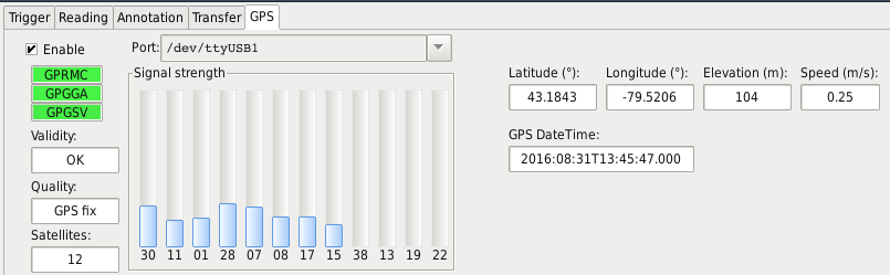
Version 1.0.0.78 of the Unihedron Device Manager (UDM) now includes integration with an external GPS receiver connected to the computer. The following image shows the GPS interface page on the Log Continuous page:


This should be useful for large land surveys where an SQM (-LE/LU/DL/R/V) and separate GPS are connected to a laptop computer while driving around collecting data for a dark sky map.

Enabling the GPS from the Log Continuous page forces "MOVING" platform logged recordings that append five fields (latitude, longitude, elevation, speed, number of satellites in view) to each record.

This feature has been tested with the GlobalSat BU-353 USB connected GPS which can be purchased from Amazon. Note: Many other GPS receivers that send standard NMEA messages at 4800 baud should also work.

This new version of UDM is available here:
Windows:http://unihedron.com/projects/darksky/cd/Windows/
Linux:http://unihedron.com/projects/darksky/cd/Linux/
Mac:http://unihedron.com/projects/darksky/cd/Mac/

The PDF manuals include a small description:
  http://unihedron.com/projects/darksky/cd/

UDM Version 1.0.0.82 has a .dat to .kml tool (Tools->dat to kml). The kml file can be opened in GoogleEarth. GoogleEarth cannot read hidden directories, so you may have to move the newly created .kml file to an easier-to-find location like the Desktop.
« Last Edit: September 04, 2018, 10:24:16 pm by admin »

admin

  • Anthony Tekatch
  • Administrator
  • Jr. Member
  • *****
  • Posts: 95
    • Unihedron
Re: GPS integration
« Reply #1 on: August 03, 2017, 07:04:51 pm »
To get the Comm Port for Windows 10 and the GlobalSat BU-353 GPS:
  • Click the Start button
  • Click the Settings button
  • Click Devices
  • Click Connected devices
  • The GPS should show up there as "Prolific USB-to-Serial Comm Port (COMx)"
  • Note which Comm port is listed, mine happens to be COM5

Start up UDM, then:
  • Make sure you meter is selected
  • Select Log Continuous
  • Select GPS tab
  • Enter the Comm Port into the Port: field, in my case I just typed in COM5
  • Click the Enable Check box, and then you should see some green indicators.
  • If the Validity indicator shows "Warning", then you may have to wait while the GPS collects enough information from the satellites. This happens faster if you are outdoors.
  • If your location appears in the Latitude and Longitude fields, then everything is ready to start logging.


To get the Comm Port for a Mac and the GlobalSat BU-353 GPS:
  • Follow the instructions provided on the CD provided with the GPS
  • Connect the GPS
  • Open a text terminal
  • cd /dev
  • ls -altr  to look for the most recently created file that looks like tty.usbserialx
  • The newly connected GPS is located at file /dev/tty.usbserialx
  • In UDM->Log-continuous->Port:, type in that filename. For me it was: /dev/tty.usbserial5
  • Click the Enable check box, and then you should see some green indicators.
  • If the Validity indicator shows "Warning", then you may have to wait while the GPS collects enough information from the satellites. This happens faster if you are outdoors.
  • If your location appears in the Latitude and Longitude fields, then everything is ready to start logging.


« Last Edit: August 04, 2017, 10:44:48 am by admin »

admin

  • Anthony Tekatch
  • Administrator
  • Jr. Member
  • *****
  • Posts: 95
    • Unihedron
Re: GPS integration
« Reply #2 on: March 05, 2018, 06:04:10 pm »
Another GPS mapping system:
  "Road Runner"
  Report by Daniel Rosa Infantes of Sociedad Malagueña de Astronomía, 2011:
  http://darkskyparks.splet.arnes.si/files/2011/09/RoadRunner.pdf

admin

  • Anthony Tekatch
  • Administrator
  • Jr. Member
  • *****
  • Posts: 95
    • Unihedron
Re: GPS integration
« Reply #3 on: April 12, 2018, 05:38:43 pm »
I've been informed that there is a Bluetooth enabled GPS (Dual XGPS160) which also works well on a Mac with UDM.

Here is a link to that the Dual XGPS160:
http://gps.dualav.com/explore-by-product/xgps160/

« Last Edit: January 25, 2020, 04:14:34 pm by admin »

admin

  • Anthony Tekatch
  • Administrator
  • Jr. Member
  • *****
  • Posts: 95
    • Unihedron
Re: GPS integration
« Reply #4 on: May 08, 2018, 07:43:12 pm »
Unihedron sells a bracket for mounting the SQM connected metes to a car window for travelling readings:
  http://unihedron.com/projects/sqm-wm/


As well, the Unihedron Device Manager software (UDM) now comes with a tool that converts the .dat (data-logging files) to .kml files used by GoogleEarth so that the following map image (with legend) can be created:

« Last Edit: May 08, 2018, 07:53:36 pm by admin »

admin

  • Anthony Tekatch
  • Administrator
  • Jr. Member
  • *****
  • Posts: 95
    • Unihedron
Re: GPS integration
« Reply #5 on: January 29, 2020, 10:09:31 pm »
Some computers reassign the communications port at power up or re-connection, so to ensure that the UDM can recognize both the SQM and the GPS, please follow these steps:
  • Disconnect the SQM and GPS from computer before powering up.
  • Power up the computer.
  • Start up UDM.
  • Connect the SQM and ensure you get a reading.
  • Disable the GPS connectivity from the log continuous tab.
  • Connect the GPS, and under the Log Continuous GPS tab ensure you are getting GPS location data.
  • Carry on from there.